MID-LATE HOLOCENE FLOOD EVENTS IN SOUTH-EASTERN AND CENTRAL ROMANIAN LOWLANDS (HoLFloods)
Distribuția inundațiilor la altitudini joase în centrul și sud-estul României pe parcursul Holocenului mediu și târziu
PROJECT SUMMARY AND OBJECTIVES
Project summary
In light of observed and projected increases in hydrological extremes and flood risk in Central-Eastern Europe, understanding long-term flood patterns and drivers becomes imperative for predicting flood frequency, magnitude and impacts in the Romanian lowlands. Longer and better resolved time series that extend beyond available instrumental records are thus needed to capture the full range of hydrological variability. In this context, this project aims to reconstruct flood patterns and quantitative flood frequency/magnitude in two distinctive Romanian lowland areas (north-eastern Transylvania and south-western Dobrogea) for the mid-late Holocene (last 6000 years), using two high-resolution lacustrine archives. Further, new paleoclimate and paleo-vegetation/fire reconstructions will be provided to assess the long-term role of climate and land-use as drivers of flood occurrence. The project will use a multi-proxy, interdisciplinary approach which integrates novel and established methods to extract the palaeoflood history (abiotic sediment properties, catchment fingerprinting), calibrate flood chronology (sediment traps, gauge station/meteorological data, documentary data, novel statistical methods) and reconstruct climate and land-use controls (GDGT palaeothermometry, leaf-wax n-alkanes as proxy for dry conditions; pollen, charcoal, dung fungal spores and archaeological information as proxies for land-use change and anthropogenic disturbance). The estimated results will potentially contextualise local to regional flood frequency/magnitude estimates and mechanistically explain long-term patterns of flood occurrence and thus provide reliable assessments of flood-related risks to ecosystems and infrastructure.
Project Number: PN-III-P1-1.1-TE-2019-1628
Funded By: UEFISCDI
Host Institution: Ștefan cel Mare University, Suceava
Objectives
1) Develop the sedimentary palaeoflood records based on the two high-resolution lacustrine archives.
Research questions: Which are the stratigraphical signatures of discrete flood layers in the two sediment records? How were flood-rich and flood poor phases distributed over the mid-late Holocene? Are there regional flood patterns, i.e., common between the two sites, and /or synchronous with patterns in Central and Western Europe?
2) Calibrate the flood chronology against independent river flow and meteorological data (last 50/100 years), sediment traps (1-1.5 years) and documentary information (last 500 years); followed by incorporation of the palaeoflood record in the frequency/magnitude analysis.
Research questions: Which is the discharge/precipitation threshold (mc/s; mm) which controls the flood unit preservation? Is there any relationship between flood layer thickness and the magnitude of river discharge / precipitation amounts? What is the frequency/magnitude of mid-late Holocene palaeoflood events? Are the flood events of the last 50/100 years in Romania unprecedented?
3) Explore the medium to long-term climatic and land-use related drivers of flood occurrence (including disturbances by fire, grazing, clearance), using new and published palaeoclimatic information.
Research questions: Do warmer and/or drier periods correspond to higher frequency and/or magnitude of flood events? How do flood-rich/poor phases relate to Rapid Climate Changes? Do atmospheric modes and pressure systems (e.g., North Atlantic Oscillation, Atlantic Multidecadal Oscillation, Siberian High) and/or solar activity exert some control over the timing and duration of regional flood rich/poor phases, over flood frequency and/or magnitude? Are there particular human activities/disturbances that correlate with flood-rich/ poor phases? Has flood frequency/magnitude increased with land-use change and extension of settlements?
TEAM

Gabriela Florescu
PI (Early Career Researcher)
Sedimentary geochemistry and magnetic mineralogy, fire and vegetation dynamics, catchment erosion, environmental change

Gheorghe Bădăluță
PhD student
Flood events in documentary records, sediment analysis

Ancuța Petraș
PhD student
Fire history, palaeo-environmental change, human impact

Vasilică Dănuț Horodnic
PhD student
Cartography, landscape morphology

Marcel Mîndrescu
Assoc. Prof. (Established Researcher)
Geomorphology, hydrology, palaeolimnological reconstruction
STUDY SITES AND PHOTOS
STUDY SITES
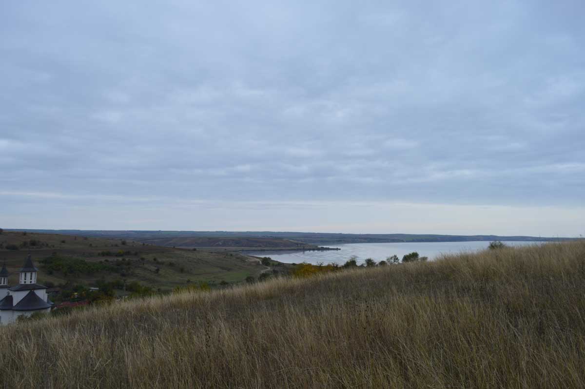
Lake Oltina
44.160453 N, 27.637889 E
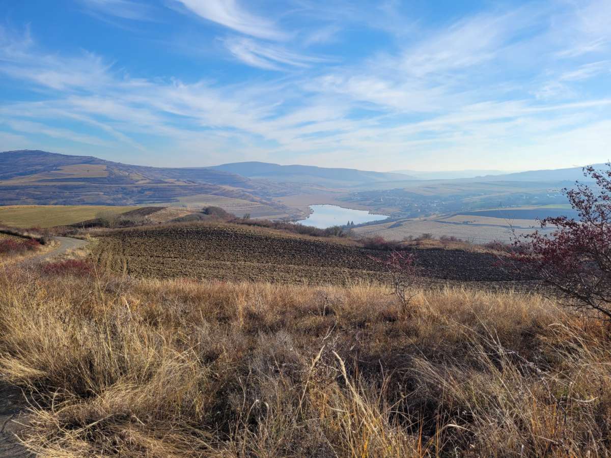
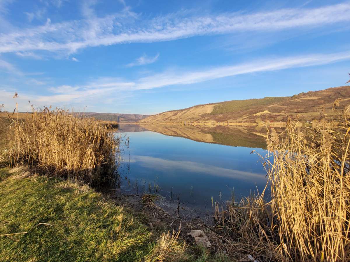
Lake Țaga Mare
PHOTOS
Lake Oltina


Lake Țaga Mare


RESULTS AND DISSEMINATION
Conferences
1. Gheorghe Bădăluţă, Angelica Feurdean, Simon M. Hutchinson, Marcel Mîndrescu, Gabriela Florescu. Paleoenvironmental changes in the lowlands of Transylvania (Central Eastern Europe) during the Late Holocene. 6th PAGES Open Science Meetings (OSM), 16-20 mai 2022 (comunicare orală).
2. Ancuța Petraș, Marcel Mîndrescu, Simon Hutchinson, Gabriela Florescu. The shaping of Late Holocene fire regimes in mid elevation mountains: a peat-based multiproxy study in the Romanian Carpathians. 6th PAGES Open Science Meetings (OSM), 16-20 mai 2022 (comunicare orală).
3. Gabriela Florescu, Marcel Mîndrescu, Gheorghe Bădăluță, Simon M. Hutchinson, Angelica Feurdean. Erosion patterns over the Holocene in the central and southeastern Romanian lowlands. First results from the HoLFloods project. 37th Romanian National Symposium on Geomorphology (SNG 2022). Geomorphology under modern challenges: uncertainties and perspectives. Sinaia, 15-19 iunie, 2022.
4. Gabriela Florescu – Descifrarea transformărilor mediului local în bazinul hidrografic al Lacului Țaga Mare în ultimii 4000 ani pe baza studiului sedimentelor lacustre. Colocviul „Trăind cu Râurile”, Proiect RYA 20-22 mai 2022, Cluj-Napoca, Romania (comunicare orală).
5. Ancuța Petraș, Marcel Mîndrescu, Gabriela Florescu. A review of charcoal as a fire proxy over the late Holocene in Romania. Landscape Archeology Conference (LAC) 2022. Vatra Dornei (sesiune in format fizic), 12-16.09.2022 (comunicare orală).
6. Gheorghe Bădăluţă, Marcel Mîndrescu, Angelica Feurdean, Simon M. Hutchinson, Dirk Nowacki, Gabriela Florescu. Erosion, landscape change and anthropogenic intervention in the Transylvanian lowlands during the Holocene. Landscape Archeology Conference (LAC) 2022. Vatra Dornei (sesiune in format fizic), 12-16.09.2022 (comunicare orală).
7. Gabriela Florescu, Marcel Mîndrescu, Gheorghe Bădăluță, Simon M. Hutchinson, Angelica Feurdean. Erosion dynamics over the Holocene in the lowlands of Romania, based on two high-resolution lacustrine archives. Results from the HoLFloods project. The 5th Conference on Regional Climate and Environment Dynamics: Climate and Environmental Changes in Central-Eastern Europe. Past, Present and Future (CECCEE-2022). 24-27 noiembrie 2022, Vatra Dornei, Romania.
8. Carmen-Andreea Bădăluță, Aritina Haliuc, Ionel Popa, Gheorghe Bădăluță. Variabilitatea spațială și temporală a secetelor din România în perioada 1901-2021 (Spatial and temporal variability of droughts in Romania over the period 1901-2021). The International Symposium Environmental Quality and Land use, XIVth edition (Simpozionului Internaţional „Calitatea mediului şi utilizarea terenurilor” ediţia a XIV-a), 9-10 iunie 2023, Suceava (comunicare orală).
9. Gabriela Florescu, Simon M. Hutchinson, Gheorghe Bădăluță, Marcel Mîndrescu, Ancuța Petraș, Angelica Feurdean. Reconstituirea frecvenței și cauzelor inundațiilor la scară milenară pe baza a două arhive sedimentare lacustre din centrul și sud-estul României (Reconstructing millennial-scale flood frequency and drivers: Insights from two lake sediment archives in central and southeastern Romania). The International Symposium Environmental Quality and Land use, XIVth edition (Simpozionului Internaţional „Calitatea mediului şi utilizarea terenurilor” ediţia a XIV-a), 9-10 iunie 2023, Suceava (comunicare în plen).
10. Anișoara Filip, Marcel Mîndrescu, Gheorghe Bădăluță, Ancuța Petraș, Gabriela Florescu. Postglacial environmental and human habitation dynamics in the north-eastern lowlands of Romania, derived from a new peat archive and archaeological data. The XXI INQUA Congress, 13 – 20 Iulie 2023, Roma, Italia. Sesiunea 30: A multiscale geoarchaeological approach for the interpretation of palaeo-landscapes and human activities (comunicare orală).
11. Gheorghe Bădăluță, Marcel Mîndrescu, Angelica Feurdean, Dirk Nowacki, Simon Hutchinson, Gabriela Florescu. Erosion history, landscape dynamics and human presence during the Holocene in the Lake Țaga catchment, Transylvanian lowlands, Romania. The XXI INQUA Congress, 13 – 20 Iulie 2023, Roma, Italia. Sesiunea 138: Wet Environments and Human Communities: Interaction and Resilience in the Holocene and Antiquity (comunicare orală).
12. Gabriela Florescu, Marcel van der Meer, Petr Kuneš, Iuliana Popa Vasiliev, Richard Chiverrell, Andreas Mulch, Vachel Kraklow. Sedimentary biomarkers and leaf wax hydrogen isotopes reveal complex Holocene climatic and environmental dynamics in the Sumava Mountains, Central Europe. The XXI INQUA Congress, 13 – 20 Iulie 2023, Roma, Italia. Sesiunea 14: Climate and environmental changes during the Holocene and past interglacials based on biological and geochemical proxies (comunicare orală).
13. Gheorghe Bădăluță, Marcel Mîndrescu, Angelica Feurdean, Simon Hutchinson, Dirk Nowacki, Gabriela Florescu. Reconstructing 6000 years of lake level variation in central Transylvania, Romania. The 7th Conference on Regional Climate and Environmental Dynamics: Geoscience in The Carpathian and Black Sea Region (GCBS 2023) – INQUA Regional Meeting. 14 – 17 septembrie 2023, Vatra Dornei, Romania
Papers
Marcel MINDRESCU, Ancuța PETRAS, Vanessa PY-SARAGAGLIA, Cécile BRUN3, Ionela GRĂDINARU, Nicolaie HODOR, Aurelian-Nicolae ROMAN & Mihaela DANU. The complementary use of charcoal number and morphology to reconstruct fire history in a Late Holocene peat sequence from NW Romania. Carpathian Journal of Earth and Environmental Sciences, February 2023, Vol. 18, No.1, p. 15 – 25; DOI:10.26471/cjees/2023/018/237
More papers coming soon
Reports
Raport științific final 2021-2023.pdf
Rezultate principale
Lacurile reprezintă capcane eficiente pentru acumularea sedimentelor, înregistrând continuu procesele de suprafață care au loc in bazinul lor hidrografic (eroziune, alunecări de teren, dinamica albiilor de râu, alterarea rocilor etc.) în special cele rezultate din variabilitatea hidro-climatului. Spre exemplu, în timpul inundațiilor, sedimentele în suspensie constituite din materiale detritice, cum ar fi fragmente litice sau granule minerale erodate de pe suprafața bazinului hidrografic, se depun pe fundul lacului, formând strate detritice distincte. Aceste strate sedimentare discrete diferă de sedimentarea de fond și pot fi identificate pe baza analizei proprietăților lor fizice și geo-chimice. Spre exemplu, stratele detritice pot avea o granulație mai mare a particulelor componente, o concentrație mai ridicată de elemente chimice detritice precum titan, rubidiu sau zirconiu și proprietăți ale mineralelor care reflectă caracteristicile rocilor din bazinele hidrografice ale lacurilor.
Prin identificarea acestor strate detritice, devine posibilă obținerea unor serii de timp privind frecvența inundațiilor, care se întind pe mii de ani. Măsurătorile la stațiile hidrometrice și datele meteorologice din România nu acoperă decât ultimii 70-100 ani, iar acest interval de timp este insuficient pentru evaluarea inundațiilor de mare anvergură cu o probabilitate de producere mai mare de 100 ani. O astfel de cronologie a frecvenței inundațiilor la scară milenară, obținută pe baza arhivelor lacustre, rezolvă limitările temporale ale măsurătorilor instrumentale și facilitează o evaluare mai cuprinzătoare a riscurilor viitoare la inundații. Mai mult, evaluarea frecvenței inundațiilor în contextul variabilității climatice și a dinamicii vegetației și utilizării terenului din trecut permite o înțelegere mecanicistă pe termen lung a factorilor de control ai acestor evenimente hidrologice.
În cadrul proiectului HoLFloods, am valorificat potențialul a două arhive sedimentare lacustre situate în nord-estul Transilvaniei (Lacul Țaga Mare) și respectiv sud-estul Dobrogei (Lacul Oltina), pentru reconstituirea frecvenței paleoinundațiilor. Cele două lacuri au fost selectate pe baza grosimii stratului de sedimente, morfologiei cuvetei lacustre și friabilității rocilor din bazinele hidrografice aferente. Din partea centrală a lacurilor au fost extrase câte o carotă de sedimente de pe întreaga grosime a stratului sedimentar. Vârsta sedimentelor a fost stabilită datând o serie de niveluri sedimentare prin metoda radiocarbonului, iar ratele de acumulare ale sedimentelor au fost modelate statistic pe baza vârstelor obținute. Rezultatele au arătat faptul că ambele arhive sedimentare lacustre acoperă aceeași perioadă de timp, respectiv ultimii ca. 6000 ani. Rata de sedimentare este în medie de 30 ani/cm în cazul Lacului Țaga Mare și respectiv 10 ani/cm în cazul Lacului Oltina.
A fost determinată compoziția fizică și geo-chimică a celor două carote de sedimente, și prin comparare cu compoziția chimică a solului și rocilor din bazinele hidrografice aferente au fost identificate stratele detritice depuse în timpul inundațiilor. În urma separării statistice a acestor strate detritice de sedimentarea de fond, am reconstituit cantitativ frecvența episoadelor cu inundații pe parcursul ultimilor 6000 de ani. Deciziile statistice au fost luate pe baza ratei de acumulare a sedimentelor în cele două lacuri, astfel că fiecare episod detritic identificat însumează semnalul inundațiilor petrecute în intervale de 10 ani la Oltina și respectiv 30 ani la Țaga Mare.
În ciuda caracteristicilor diferite ale celor două zone de studiu (litologie, hidrografie, influențe climatice) se poate observa o grupare similară a perioadelor cu inundații acum 6000-5500 ani calibrați înainte de prezent, urmată de o perioadă mai liniștită între 5500 si 3400-3500 ani calibrați înainte de prezent, întreruptă de o creștere a frecvenței inundaților care atinge maximul în ultimele doua milenii (4 episoade cu inundații majore la fiecare 500 ani la Oltina și la fiecare 1000 ani la Țaga Mare). Frecvența inundațiilor urmează o tendință descendentă în ambele zone de studiu pe parcursul ultimilor 500 ani. Inundațiile extreme din ultimul secol au fost identificate în arhiva sedimentară a Lacului Oltina, însă nu și în cea a Lacului Țaga Mare.
În perioadele în care frecvența inundațiilor a crescut (3400-2600, 2000-500 ani calibrați înainte de prezent), au avut loc schimbări dramatice în structura și compoziția vegetației în ambele zone de studiu, respectiv scăderea suprafețelor de teren acoperit cu arbori și creșterea suprafețelor acoperite cu vegetație ierboasă și specii cultivate. Frecvența incendiilor de vegetație a crescut concomitent cu scăderea suprafeței împădurite, ceea ce confirmă utilizarea incendierilor repetate pentru extinderea zonelor agricole și desțelenirea pășunilor. Din punct de vedere al influenței factorilor climatici, rezultatele indică o tendință de grupare a episoadelor cu inundații în timpul fazelor pozitive ale Oscilației Nord Atlantice (NAO), mai evidentă după intensificarea impactului antropic.
Tendința de creștere a frecvenței inundațiilor în ambele zone de studiu concomitent cu reducerea suprafețelor împădurite și intensificarea utilizării terenului a devenit așadar vizibilă în timpul Epocii Bronzului Târziu (acum 3400-3500 ani) și a atins punctul maxim începând cu Perioada Romană. Prin urmare, evidențiem importanța managementului acoperirii terenului în gestionarea pe termen lung a riscului la inundații.